Friday, October 28, 2016

Torontonian Map of Toronto

Next week the GIS-Pro conference opens in Toronto. To help people navigate their way to and around the area, here is a map from the locals.
http://imgur.com/r/TOmaps/4rTqyxx
Judging from this zoomed in view of the area, you can now take the subway all the way to Lake Simcoe for some weekend foliage viewing. It's also helpful that they built a diagonal road from NYC to Buffalo.
Also, they move the British Isles much closer for your convenience.
Hope this map helps you enjoy your stay!

Wednesday, October 26, 2016

Land of Grated Cheese

This map hangs on the wall of my local cheese shop.
https://bolognauncovered.files.wordpress.com/2012/07/zona-di-produzione.jpg
It shows the "zone of production" for Pamigiano-Reggiano cheese. This includes the provinces of Parma, Reggio-Emilia, Modena and parts of Bologna and Mantua. The map has lots of nice quaint details but is also more geographically accurate than many pictorial maps.
According to Wikipedia, a combination of the morning's whole milk and the previous evening's skim milk are heated in copper vats, as in the detail above. The cheese is cooled, put into a wheel form and washed with brine. It is then aged for 12-30 months before it can be sold in town.
Or worn on your head -
- though Packers fans seem to prefer Swiss.

Wednesday, October 19, 2016

Favorite Maps-Part 3

 Swiss topographic maps have set a standard for cartographic excellence since 1838.

Since the early 1960's these maps have been based on the pioneering relief shading of Eduard Imhof.
Imhof employed the concepts of natural vision where colors of nearby objects are brighter than more distant objects. In the case of a map (from an overhead perspective) the higher elevations get the brightest colors, while the lowest elevations are a grayish blue tint. The map is illuminated obliquely from the left side and is enhanced by contour lines and rock drawings.

 The online interactive version seamlessly integrates raster information (scanned paper maps) with vectors (geodata) to the extent that it is often unclear which you are seeing. As you zoom out, the map seemlessly changes scale, while retaining its beauty.


I am also fascinated with the way they generalize features - as you zoom out buildings and other shapes simplify, merge and eventually disappear. Click below for a more legible image.
You can wander through the Swiss mountains here and/or purchase paper maps here.

Note - this is the last of the "Favorite Maps" series for now but I may have additional installments in the future.

Tuesday, October 11, 2016

Favorite Maps-Part 2

Erwin Raisz - Landforms of the United States, 1957
http://www.davidrumsey.com/luna/servlet/detail/RUMSEY~8~1~231095~5508485
Raisz was a Hungarian civil engineer. When he came to the United States he began working for the Ohman Map Company in New York City where he also taught one of the nation's first cartography classes at Columbia University. Eventually he ended up at Harvard University where he also curated their excellent map collection. His artistic talent, memory, eye for detail and scientific knowledge combined to make a remarkably detailed and beautiful map.
I first encountered this map in 1991 when working on the Historical Atlas of Massachusetts. We used the map as a backdrop for the a graphic showing the geology and ecology of the northeastern United States.
http://www.geo.umass.edu/faculty/wilkie/Wilkie/hist_mass_p3.jpg
 I've been fascinated with this map ever since. Here are some nice details.
He uses some gorgeous hand lettering-especially for the water features. Note the ancient glacial lake shoreline at the western edge of this section. I'm also intrigued by his space saving labeling of smaller cities ("S" for Sandusky, "Y" for Youngstown, etc.) This is one example of the kind of unconventional techniques that make me uncomfortable, but in a good (teaching moment) kind of way.
Another unconventional technique - where the landforms were either less well explored or not available, he created a mostly empty space with the text "Laurentian upland of low hills and many lakes." I find it curious that Mexico is mostly empty, except a small area along the California and Arizona boundaries, while Canada is mostly filled in.
The legend showing multiple features in one box - another unconventional but very successful approach.

 Dramatic landscapes look great...
...but even in mostly flat areas, such as this part of Kansas, he still managed to keep the features interesting.
You can browse this map from the David Rumsey Map Collection.

Raisz created similar maps for regions around the world.
A list of his and purchase prices can be found at the Raisz Landform Maps web page.

Wednesday, October 5, 2016

Favorite Maps-Part 1

People often ask me what my favorite map is. For whatever reason I don't do well with favorites. I don't have a favorite map, or song, book, etc. In attempt to answer I will post three separate maps (possibly more if they come up) that are among my favorites over the next few weeks. The order of these map does not reflect preference. If anything they will be ordered from closest to farthest away.

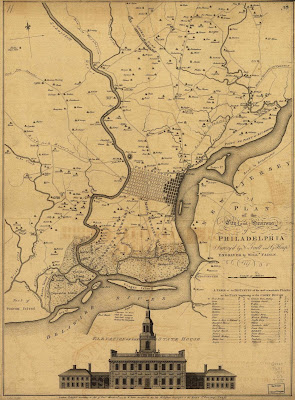
The first map is the one that appears in the header image of this blog. It also appears on my dining room wall. I've discussed this map before in public so some of you have heard my spiel before - sorry in advance for repeating myself.
http://www.mapsofpa.com/18thcentury/1777fadenscullheap.jpg
A PLAN OF THE CITY AND ENVIRONS OF PHILADELPHIA. Surveyed by N. Scull and G. Heap. Engraved by Willm. Faden 1777

Having spent much of my childhood in Philadelphia, this map resonates with me. I like looking at very urban areas I know fairly intimately and seeing them as farms or quaint villages. I realize they were probably not as quaint as they look on the map but it's fun to entertain that fantasy. There are many nice details such as...
The quaint, industrial village of Frankford, now sitting under an elevated subway line. A similar map is shown on a mural underneath the tracks as highlighted in a previous post. As seen throughout the map, homesteads are listed by family name. Many of these names are still prevalent in area place names.
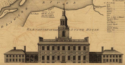
Elevation of the State House (now Independence Hall)
The entanglements laid across the river to disrupt navigation and protect the city in wartime. Also notice the nice flow lines in the river and around the islands. Those of us familiar with the city will also appreciate how much land has been filled in. The river is much narrower now and many of these islands are now part of the mainland. Many of the rivers and channels here are now underground. Also, I like that Red Bank shows up. I was born in Red Bank, New Jersey - a different (much larger) one.
I'm pretty sure that the shaded blocks are what was actually settled and the unshaded blocks were laid out but not yet built.
Point No Point!

Other nice details include forts, swamps. ferries, America's first paper mill, the calligraphy in the title block, and the table of distances to the "moft remarkable PLACES."