
There are lots of best maps of the year posts on other sites. You could spend hours looking at the Maps Mania 100 Best Maps of the Year - not a bad way to spend your time if you have it. I also highly recommend Cartonerd's favorite maps list. I am not nearly that ambitious, nor can I pretend to have seen every good map that has been made in the past year. Instead, I will show three maps that I never got a chance to post during the year. I really like these, but will make no claims about their "best"-ness.
The Magnificent Bears of Finland - Annukkah Makijarvi*
 This is a deceptively simple looking density map showing the population of bears by area.** If you look closely though the areas are made of of bears. A great synthesis of art and cartography.
 * I think this map may be a couple of years old by now but it made the rounds on the map sites this year.
** Not completely sure what the areal unit used here, a sort of bear grid perhaps.
Longyearbyen and Environs - Norwegian Polar Institute.
 This map shows an area of Svalbard, an Arctic island off Norway. It is another artistically beautiful map. The International Cartographic Association's Map of the Month for November, 2015. Here are two zoomed in details.

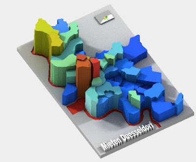
 Sculpteo's 3-D Printed Maps
These "datasculptures" can be rotated in three dimensions, even in their preview views. They include several demographic maps, mostly from Germany. This example shows rents in Dusseldorf.
Looking forward to another year of mappy goodness!
The Magnificent Bears of Finland - Annukkah Makijarvi*

** Not completely sure what the areal unit used here, a sort of bear grid perhaps.
Longyearbyen and Environs - Norwegian Polar Institute.


These "datasculptures" can be rotated in three dimensions, even in their preview views. They include several demographic maps, mostly from Germany. This example shows rents in Dusseldorf.
Looking forward to another year of mappy goodness!


No comments:
Post a Comment